
 BBC
BBCHumanitarian organisations and journalists have expressed concerns after a leading satellite imagery company told its users it was restricting access to images of Iran and large parts of the Middle East following a request from the US government.
California-based Planet Labs initially introduced a 14-day delay on providing new imagery from the region in March. It has since moved to an "indefinite" restriction.
The decision has limited how journalists, humanitarian groups and analysts can use satellite images to assess the impact of the US-Israel war with Iran, including damage to military targets and civilian infrastructure.
It is unclear what prompted the US to press Planet to suspend its coverage and the Department of Defense did not respond to a request for comment.
Planet initially said its original 14-day delay policy was "to ensure our imagery is not tactically leveraged by adversarial actors to target allied and Nato-partner personnel and civilians".
It said in a statement to BBC Verify that it was now switching to a system of "managed distribution" and would share selected images "on a one-off basis until the security risk has abated".
It declined to say how extensive the restrictions were. But based on BBC Verify's access to the portal it appears to extend across most of the Middle East, including Iraq, Lebanon, Israel and Gaza.
One satellite imaging expert told BBC Verify that companies like Planet that have military contracts can sometimes implement "voluntary compliance" requests that are actually "driven by commercial incentive structures".
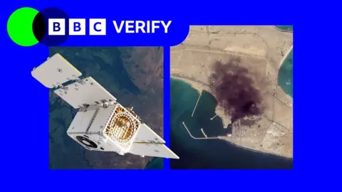
BBC Verify has used Planet imagery across the Middle East in its reporting, including since the war in Iran began at the end of February - such as when a US strike on a school in the Iranian town of Minab.
The changes now mean that images taken after 9 March are no longer routinely available to the company's clients.
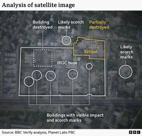 BBC Verify used satellite imagery from Planet to investigate US strikes on a school in Minab, Iran
Satellite imagery has become a key tool for reporters, according to investigative journalist Benjamin Strick, who has worked for CNN, the Financial Times and the BBC.
This is especially true for "conflict zones, disasters and other restricted environments where reporters cannot safely access the scene or where information is tightly controlled", he said.
Planet's business model is similar to others in the industry. It has been expanding its work with the US defence sector, including the US National Geospatial Intelligence Agency and - through a subsidiary - the US Navy. It also works with the German and Swedish militaries.
Vantor, formerly known as Maxar, has contracts with the US Army and US Space Force and limits coverage of US military bases. However, it told Reuters earlier this week that it had not been asked by Pentagon officials to restrict its coverage of Iran.
Bill Greer, a geospatial analyst who previously worked at Maxar and co-founded the non-profit satellite service Common Space, noted that the number of defence contracts held by companies like Planet grants governments some degree of influence over them.
"What we're seeing now is voluntary compliance driven by commercial incentive structures, not legal mandates," he told BBC Verify.
"When your largest customer is also the government that regulates you, the line between voluntary and involuntary gets very thin."
Greer also observed that humanitarian groups were affected by restrictions on satellite images.
"When an entire region goes dark indefinitely, it directly affects [their] ability to plan evacuations, assess damage, document human rights abuses and co-ordinate aid delivery," he said.
The charity Oxfam told BBC Verify it used satellite imagery to plan some of its logistics during live conflicts and disasters.
The group's humanitarian lead, Magnus Corfixen, said that in Gaza - where Planet has also suspended coverage - satellite services helped it to run its water, sanitation and hygiene (Wash) programme.
"We couldn't access these water systems in person," he said. "So we tried to use satellite imagery to see whether or not they were still operational or if they had been destroyed."
He added that, based on reviews of the imagery, Oxfam then planned what equipment they needed to transport into the Strip.
BBC Verify has also relied on satellite imagery to report on changes and damage in Gaza, since Israel does not allow media to send journalists independently into the Strip. There have previously been delays on imagery from Gaza, but never to this extent.
Todd Harrison - a senior fellow at the American Enterprise Institute and ex-US Air Force captain - told BBC Verify that the Iranian military had limited satellite surveillance capability of its own, making it heavily reliant on Russia, China and "whatever imagery they can acquire from commercial providers".
"US and European commercial firms have some of the best space surveillance capabilities in the world," he said.
"This data would be enormously valuable to Iran in its efforts to strike targets across the Middle East... and to assess the effectiveness of its strikes."
There have also been concerns that bad actors have also seized on the restrictions placed on Iranian imagery to proliferate fakes online.
Amir Farhand - founder of Soar.Atlas, an Australian mapping platform that uses satellite images - told BBC Verify that it had tracked "a massive spike in fake satellite imagery during this conflict", adding that the trend was "becoming a serious problem".
In the absence of Planet's services, its news clients - such as the BBC and the New York Times - have been turning to non-US based solutions.
But Christoph Koettl, a visual investigations journalist with the New York Times, said that the resolution offered by some of these services - like the European Space Agency - did not offer the same level of detail or widespread coverage.
"The imagery is blurrier. I cannot distinguish between cars, vehicles, things like that," he said. "With a provider like Planet Labs, the advantage is that they're imaging almost every place on Earth once a day."
Harrison said he expects restrictions like those requested of Planet to become more common, but increasingly more futile as the industry expands and new providers emerge across the globe.
"Because dual-use technology like this has become increasingly democratised, it is making the modern battlefield more transparent for both sides than ever before," he said.
"That is a fact of life the US and others will have to adapt to in how they plan and conduct military operations."

What claims do you want BBC Verify to investigate?
IranReconnaissance satellitesIran war